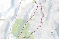
Today’s anticlockwise circular hike starts from the Leitrim Lodge car park. The hike takes in gravel trails, forest trails and open mountain.
Starting from the car park follow the gravel trail heading towards Rocky Mountain. After a few hundred meters take the gravel trail to the right going through the gate. Once on this trail you should be heading SSW.
Keep following this trail. You will eventually arrive at a recently felled forest. Here the track becomes narrow once you cross over the stream. It can get very muddy in places if it has rained recently.
Following this track until you reach a style. Once over the style you will join a wider gravel track.
Follow this track until you reach a bridge. Crossing the bridge will take you to the Yellow River picnic area if you want to stop for a break. To continue the route take the small gravel trail to the left of the bride and follow the steep ravine until you break out of the forest on to a wide gravel trail. Turn right here.
After a hundred meters or so take the left fork to head east. After a few hundred meters you will find a forest trail on the left marked by a large stone. Keep following this trail NE and you will soon break out of the forest. Once over the fence you will find a feint but easily found trail on the open mountain. Continue on this trail until you meet Batt’s Wall and cross it.
Follow this trail and soon you bear right and then bear left to take the middle track across the very flat Altataggat Mountain. You will see Pierce’s Castle in the distance to your right.
Once you have crossed Altataggart mountain keep descending on the gravel track which will take you back the Leitrim Lodge car park.
A GPS trace is available for this route, please Contact us.
Statistics
Length: 11km
Elevation Gain: 380m
Elevation Loss: 380m
Highest Point: 469m (Tievedockaragh / Batt’s Wall)
Lowest Point: 161m (Car Park)
